Lake Tahoe Map
Below you will find a Lake Tahoe Map that shows the Lake Tahoe Cities and Towns around the Lake. Eventually, I'll have a summary page for each town. For basic information about Lake Tahoe, please see my Lake Tahoe page! For beach information, please see my Lake Tahoe Beaches page!
View Larger Map
Here are some tips for using the map:
- If you don't have to Search for directions, you can close the White Box in the middle of the screen by clicking on the top right X in the box.
- The arrows move you up, down, left, and right (or grab the screen and pull in any direction)
- The + and - zoom you in and out
- The "Map" button, (the default view) shows Lake Tahoe in map illustration form.
- The "Satellite" button shows Lake Tahoe in satellite images (zoom in for detail)
- The "Terrain" button shows an artistic rendering of the terrain that covers Lake Tahoe (zoom out to use this feature).
- The "Earth" button switches over to Google Earth which is fantastic! You can explore the area as if you were actually there!
Lake Tahoe Cities and Towns
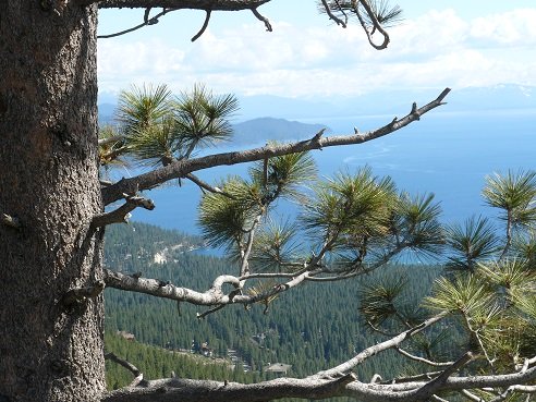
Incline Village and Lake Tahoe as viewed from the Mt. Rose viewpoint
These are the Lake Tahoe Cities and Towns that the Truckee Travel
Guide website will have a page with the highlights of the town: (links
coming soon!)
- Agate Bay
- Carnelian Bay
- Crystal Bay
- Dollar Point
- Glenbrook
- Homewood
- Incline Village
- Kings Beach
- Meeks Bay
- South Lake Tahoe (California)
- Stateline (Nevada)
- Tahoe City
- Tahoe Vista
- Tahoma
- Zephyr Cove
State Parks
The State Parks that can be viewed on the Lake Tahoe Map, that I will be covering include:
- California State Parks:
- Burton Creek State Park
- Donner Memorial State Park - Truckee
- D.L. Bliss State Park
- Emerald Bay State Park
- Kings Beach State Recreation Area
- Sugar Pine Point State Park
- Tahoe State Recreation Area
- Nevada State Parks:
- Lake Tahoe Nevada State Park
- Sand Harbor State Park
Like This Page?
Please Check out my other Websites!

Healthy Diet Habits:
Holidays and Observances
U.S. and World Holidays - Over 6,000 so far!
Related Pages






New! Comments
Have your say about what you just read! Leave me a comment in the box below.